

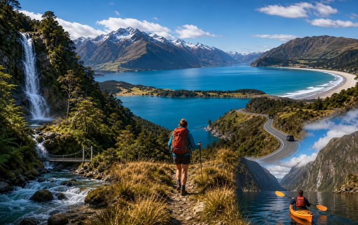
Outdoor Adventure Routes Across New Zealand: Trails, Waterways, and Wild Roads
New Zealand's compact size hides a huge variety of landscapes, from volcanic plateaus and beech forests to glaciers and wild coasts. For adventure travelers, that diversity translates into a dense network of routes that can be linked into multi-day journeys on foot, by bike, by paddle, or behind the wheel. Rather than listing every trail in the country, this guide focuses on some of the most compelling adventure routes, how they differ, and what to consider for safety, logistics, and performance when planning a trip. For adventurous individuals used to alpine treks in Europe, desert trails in the United States, or jungle routes in Southeast Asia, New Zealand's combination of well-developed infrastructure and genuinely remote terrain can feel unique. Many routes are clearly waymarked and supported by hut networks, yet weather, river crossings, and isolation demand serious preparation.
Understanding New Zealand's Adventure Landscape
New Zealand's adventure routes fall broadly into three categories: walking and tramping tracks, cycle trails and bikepacking routes, and water-based journeys. These often intersect, making it possible to design hybrid itineraries that combine, for example, a multi-day hike with a sea-kayak section or a gravel-bike link.
The Department of Conservation (DOC) manages a large proportion of backcountry tracks and huts, including the famous Great Walks. DOC's official track classifications-from "short walk" to "advanced tramping track"-are a useful starting point, but many routes in this article sit at the more demanding end of that spectrum. New Zealand's safety agencies, including AdventureSmart and MetService, consistently emphasize that conditions can change rapidly, especially in alpine and coastal regions, and that river levels and avalanche risk can turn a straightforward outing into a serious undertaking with little notice.
Travelers also need to be aware of cultural and environmental dimensions. Many routes cross land that is significant to Māori iwi and hapū, and some areas have access protocols or rāhui (temporary restrictions) following incidents or to protect ecosystems. Biosecurity is another recurring theme: trampers and bikers are urged to clean gear to prevent the spread of kauri dieback disease and invasive species, and to follow local guidelines when moving between catchments.
For those planning broader itineraries that string together several regions, it can be useful to think in terms of adventure "corridors": alpine routes centered on the Southern Alps, coastal and island journeys, central North Island volcanic terrain, and long-distance traverses that cut across multiple landscapes. These align naturally with New Zealand's reputation as a destination for adventure travel and can be combined with urban culture, food, and innovation hubs in Auckland, Wellington, and Christchurch.
Classic Multi-Day Tramping Routes
New Zealand's multi-day tramps range from hut-to-hut journeys on manicured trails to rough backcountry routes requiring navigation skills. While the Great Walks receive the most attention, several other tracks offer similarly powerful experiences with fewer crowds.
The Milford Track in Fiordland, often marketed as one of the world's great hikes, is a four-day journey through rainforest, alpine passes, and deep fiords. Managed as a Great Walk, it features well-maintained tracks and serviced huts, but capacity is limited and bookings via DOC's Great Walks booking system are essential in season. The nearby Routeburn Track and Kepler Track offer shorter loops and traverses with significant alpine sections and are often combined in regional itineraries out of Queenstown and Te Anau.
For those seeking something more rugged, the Rees-Dart Track north of Queenstown, though partially affected in recent years by landslides and track damage, has long been a staple of South Island tramping. DOC's Rees-Dart information highlights ongoing repair work and route changes, underlining the importance of checking the latest alerts. Further north, in Nelson Lakes National Park, the Travers-Sabine Circuit delivers a more remote feel, linking lakes, passes, and beech forest in a loop that rewards experienced trampers comfortable with river crossings and variable weather.
On the North Island, the Tongariro Northern Circuit (another Great Walk) circles active volcanoes and passes emerald lakes and steam vents. It shares part of its route with the heavily trafficked Tongariro Alpine Crossing, but the full circuit offers quieter sections and a stronger sense of immersion in the volcanic plateau. Because it traverses an active volcanic area, authorities maintain detailed risk information and alerts via GeoNet, and DOC may temporarily close sections in response to activity or severe weather.
These multi-day routes sit naturally alongside New Zealand's broader adventure culture, and many visitors combine them with other pursuits such as mountain sports or backcountry running. For those looking beyond the headline Great Walks, DOC's regional pages and local tramping clubs provide extensive route suggestions and condition reports.
The Te Araroa Trail: A Country-Length Traverse
The Te Araroa Trail-"the long pathway"-runs roughly 3,000 kilometers from Cape Reinga at the top of the North Island to Bluff at the bottom of the South Island. Completed in 2011, it stitches together beaches, urban walkways, farmland, forests, and alpine sections into a thru-hike that typically takes three to six months.
Unlike many national trails in Europe or North America, Te Araroa is a patchwork of existing tracks, new links, and road sections. The Te Araroa Trust maintains detailed route notes, maps, and alerts on its official website, and strongly encourages hikers to register, both for safety and for data that helps guide track development. Sections like Ninety Mile Beach, the Tararua Range, and the Richmond Ranges are physically demanding and can be hazardous in bad weather, while road-walking segments raise different kinds of safety questions around traffic and visibility.
Te Araroa has become a focal point for long-distance hiking culture in New Zealand, with a growing community of international thru-hikers and local "section hikers" completing individual parts. It has also sparked debates about environmental impact, crowding, and respect for private landowners whose properties the trail crosses. The Trust works with Land Information New Zealand (LINZ) and local councils on access issues, and hikers are expected to follow strict leave-no-trace principles and respect seasonal closures.
For adventure travelers, Te Araroa can serve as a backbone around which to build a multi-month exploration of the country, with detours into nearby destinations, side trips to ski fields or surf breaks, and rest days in cities and towns. It also intersects with numerous cycle trails and river journeys, opening possibilities for "flip-flop" itineraries that mix disciplines rather than following the full route on foot.
Great Walks and Beyond: Route Quality and Access
New Zealand's Great Walks system was designed to highlight a small group of premier tracks with higher levels of maintenance, facilities, and interpretation. Alongside Milford, Routeburn, Kepler, and Tongariro Northern Circuit, other notable Great Walks include the Abel Tasman Coast Track, Heaphy Track, Paparoa Track, and Rakiura Track on Stewart Island. DOC provides comprehensive Great Walks overviews including seasonal hut pricing, booking windows, and transport options.
The Abel Tasman Coast Track is one of the most accessible multi-day routes, with water taxis, hut and campsite networks, and opportunities to combine tramping with sea kayaking. However, its tidal crossings require attention to timing and local tide charts. The Heaphy Track, spanning Kahurangi National Park between Golden Bay and the West Coast, offers a striking transition from dense forest to wild coastline and has at times allowed seasonal mountain biking, reflecting ongoing debates about multi-use trails and conservation.
By contrast, many non-Great Walk routes offer a more "backcountry" experience: rougher tracks, fewer facilities, and a stronger emphasis on self-reliance. DOC's advanced tramping tracks often involve unbridged river crossings, route-finding, and sections above the treeline where navigation in poor visibility can be challenging. For international visitors accustomed to heavily waymarked alpine routes, this difference in track standard is important to understand.
Booking systems and differential pricing have also become part of the conversation. Great Walk huts typically require advance bookings in the main season, while many backcountry huts operate on a first-come basis with hut passes or tickets. This can influence route choice for travelers who prefer more flexible itineraries or who are visiting outside peak months. It also ties into broader tourism and business dynamics, with local operators offering transport, guiding, and gear services tailored around these marquee tracks.
Cycle Trails and Bikepacking Routes
New Zealand has invested heavily in cycle infrastructure over the last decade, particularly through the New Zealand Cycle Trail / Ngā Haerenga network. This system of "Great Rides" and connecting trails covers everything from gentle rail trails to demanding backcountry singletrack, making it a natural fit for adventure cyclists and bikepackers.
The Alps 2 Ocean Cycle Trail is one of the best-known long-distance routes, running about 300 kilometers from the base of Aoraki / Mount Cook or Lake Tekapo to the coastal town of Oamaru. Its official site, alps2ocean.com, outlines sections, gradients, and transport options, and notes that while much of the route is graded for intermediate riders, weather and surface conditions can shift quickly. The trail's mix of glacial lakes, hydro canals, and rural backroads makes it a popular choice for multi-day journeys that combine cycling with local food and wine.
Further north, the Old Ghost Road has become a flagship backcountry ride. Developed along an abandoned gold-miners' route on the West Coast, it offers roughly 85 kilometers of benched singletrack, swing bridges, and high ridgelines. The Old Ghost Road trust emphasizes that this is a remote, alpine-influenced environment, and recommends strong technical skills, self-sufficiency, and careful weather planning. Bookable huts along the route allow for one- to three-night itineraries on foot or by bike.
The Timber Trail in the central North Island, built largely on old logging tramways, offers a more moderate experience with suspension bridges, forest history, and well-spaced accommodation. It is often combined with visits to the geothermal areas and adventure activities around Taupō and Rotorua, which are already established hubs for sports and performance tourism.
Bikepacking culture in New Zealand extends beyond official trails. Events like the Tour Aotearoa, a self-supported brevet that traverses the country from Cape Reinga to Bluff, use a mix of cycle trails, gravel roads, and minor highways. Route information and guidelines are hosted on the Tour Aotearoa site, which stresses environmental responsibility and safety, particularly around traffic and remote sections. These long rides intersect with wider conversations about cycling infrastructure, road safety, and how adventure routes can coexist with everyday transport networks.
Water-Based Routes: Kayaking, Packrafting, and Coastal Journeys
New Zealand's coastlines, lakes, and rivers support a growing ecosystem of water-based adventure routes, many of which can be integrated with tramping or cycling trips. Sea kayaking in Abel Tasman National Park is one of the most established options, with DOC and local operators providing kayaking guidelines that emphasize weather, tides, and marine wildlife protection. Paddlers can camp at designated sites, stay in huts, or link up with the Abel Tasman Coast Track for hybrid itineraries.
In Fiordland, guided kayaking on Milford Sound / Piopiotahi and Doubtful Sound / Patea offers a different kind of route: steep-walled fiords, waterfalls, and frequently wet, changeable conditions. Because of the remoteness and complexity of these environments, many visitors opt for guided trips, and authorities stress the importance of understanding hypothermia risk and maritime safety rules. The Maritime New Zealand agency maintains safety resources for recreational boating and kayaking, including lifejacket requirements and communication recommendations.
On inland rivers, packrafting has emerged as a niche but rapidly growing activity. Lightweight rafts allow trampers to float sections of rivers that would otherwise require long detours, opening up creative loop routes. However, New Zealand's rivers can be deceptively hazardous, with swift currents, strainers, and flash-flood potential. The Mountain Safety Council and AdventureSmart provide river safety guidance emphasizing skills training, group decision-making, and conservative judgment around weather and water levels.
Lake-based journeys, such as multi-day trips on Lake Waikaremoana (previously a Great Walk) or circuits on the central Otago lakes, can be undertaken by kayak, canoe, or in some cases stand-up paddleboard, though wind and wave conditions can quickly exceed the capabilities of casual paddlers. These water routes intersect naturally with the themes of safety and ethics, particularly in terms of respecting wildlife, avoiding disturbance of nesting birds, and adhering to local regulations on fishing and camping.
Road Trips and Overland 4×4 Routes
Not every adventure route in New Zealand is human-powered. For many visitors, multi-day road trips and 4×4 journeys provide a framework for exploring remote regions, accessing trailheads, and stringing together different sports. The classic South Island loop from Christchurch through Tekapo, Aoraki / Mount Cook, Queenstown, Fiordland, the West Coast glaciers, and back via Arthur's Pass is effectively an adventure corridor, with numerous opportunities for side trips and overnight routes.
In the North Island, circuits linking the central volcanic plateau, Taranaki, and the Coromandel Peninsula offer access to surf breaks, short alpine hikes, and mountain-bike parks. New Zealand's state highway network is relatively sparse in some regions, and many adventure travelers rely on unsealed roads and, in certain cases, 4×4-only tracks to reach more isolated start points. Waka Kotahi NZ Transport Agency maintains real-time road information that is essential for planning around closures, slips, and winter conditions.
Dedicated 4×4 routes, such as those in Molesworth Station, Skippers Canyon, and some high-country passes, raise additional safety and environmental considerations. Rental companies often restrict access to particular roads, and drivers need to be familiar with local conditions, including narrow cliff-edge roads, ford crossings, and sudden weather changes. The New Zealand Police and safety organizations emphasize driver fatigue and speed management as key risks, particularly for international visitors unused to left-hand driving and local road geometry.
Road-based itineraries also interface with New Zealand's evolving lifestyle and culture around vanlife, campervans, and freedom camping. Regulations on overnight parking have tightened in many regions due to environmental impact and local concerns, and travelers are expected to follow council bylaws and use designated campgrounds or certified self-contained vehicles where required.
Safety, Preparation, and Route Ethics
Across all these adventure routes, a consistent theme emerges: New Zealand's terrain is inviting but not forgiving. The New Zealand Mountain Safety Council reports that many backcountry incidents involve experienced individuals who underestimated conditions or overestimated their capabilities. Core safety principles-planning, communication, equipment, and decision-making-are reinforced across official resources such as AdventureSmart, which aggregates trip-planning tools, weather links, and activity-specific advice.
Weather forecasting is central to safe route choice. MetService provides mountain and marine forecasts that are more detailed than general city forecasts, while NIWA offers climate and hazard information useful for understanding seasonal patterns. Avalanche risk on alpine routes is monitored by the New Zealand Avalanche Advisory (NZAA), which publishes regional avalanche forecasts across the main mountain areas. For those venturing into snow-affected terrain outside the managed ski fields, avalanche education and appropriate rescue gear are considered essential.
Ethics and environmental responsibility are equally important. New Zealand promotes a localized version of Leave No Trace principles, encouraging visitors to pack out all waste, minimize campfire impacts, and respect wildlife and vegetation. Specific campaigns address issues such as toileting in the backcountry, drone use, and the protection of sensitive alpine and coastal ecosystems. DOC and conservation groups also run biosecurity campaigns to prevent the spread of pests and diseases, which can involve gear-cleaning stations and track-side signage.
Cultural respect forms another pillar of ethical travel. Many routes pass through land with deep significance to Māori communities, and in some cases, access is governed by agreements or protocols arising from Treaty of Waitangi settlements. Travelers are encouraged to learn basic tikanga (customs), understand the significance of place names, and be attentive to rāhui or other temporary restrictions. This aligns with broader conversations in New Zealand about ethics in tourism, including how adventure activities intersect with indigenous rights and local community priorities.
Choosing Routes for Different Adventure Styles
With so many options, the challenge for most visitors is not finding a route, but choosing one that matches their interests, skills, and time. For those focused on high-intensity sports and performance, alpine tramps, backcountry bikepacking, and technical river journeys may be the draw. For others, the appeal lies in slower, more immersive travel, combining shorter walks and rides with food, culture, and rest days in small towns.
Shorter Great Walk sections or day-hikes on the Tongariro Alpine Crossing, Roy's Peak near Wānaka, or the Hooker Valley Track near Aoraki / Mount Cook can be integrated into broader travel itineraries without committing to full multi-day routes. Families or less experienced adventurers might gravitate toward rail trails such as the Otago Central Rail Trail or gentle coastal walks in Abel Tasman, which offer a strong sense of place with lower objective risk.
Those with more time can design multi-week journeys that weave together several regions: for example, a North Island route linking the Timber Trail, Tongariro, and the Coromandel; or a South Island loop that combines the Alps 2 Ocean, Old Ghost Road, and a Fiordland tramp. In each case, logistics-transport, hut and campsite bookings, seasonality, and gear-will shape what is realistic. Local operators, regional tourism organizations, and community forums often provide up-to-date, ground-level insights that complement official information.
For adventure-minded travelers, New Zealand's routes offer more than just physical challenge. They provide a framework for engaging with the country's landscapes, cultures, and environmental debates in a direct, embodied way. Whether through a single Great Walk, a months-long traverse, or a sequence of weekend-length trips, the routes described here can be tailored to a wide spectrum of ambitions, from first-time international visitors to seasoned explorers returning for another season in the hills.